-
 U.S. Rep. Eric Sorensen has been tabbed to lead a new legislative panel on weather preparedness.
 -
 An air quality alert is in effect Monday for a second straight day in Bloomington-Normal and most of Illinois, as smoke from Canadian wildfires drifts into the U.S. The air quality locally was deemed Unhealthy for Sensitive Groups.
 -
 The National Weather Service office in Lincoln issued an extreme heat warning Tuesday that is in effect until midnight Thursday. All of Central and Southeast Illinois could see heat index values between 105 and 110 degrees Fahrenheit.
 -
 The National Weather Service confirmed 172 tornadoes have struck the state this severe weather season. That's an all-time state record, and the most for any state in the U.S. this year.
 -
 An extended run of hot temperatures and high humidity is forecast to arrive across Central Illinois on Sunday and last through most of the week.
 -
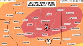 The National Weather Service is preparing for the possibility of two rounds of severe storms on Wednesday, less than one week after nine confirmed tornadoes tore through the region.
 -
 The National Weather Service has preliminary confirmation of nine tornadoes in Central Illinois on Wednesday and Thursday of last week.
 -
 No injuries have been reported in the storms that hit McLean County Thursday evening.
 -
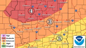 McLean County is facing an enhanced risk of severe weather (Level 3/4 of 5) for a storm expected to hit between 5 p.m. to midnight Thursday.
 -
 The National Weather Service says two of the reported tornadoes that tore through Bloomington last Friday night were actually one continuous twister. That tornado was rated an EF1 with wind speeds of up to 110 mph.
© 2026 WGLT
A public service of Illinois State University
Play Live Radio
Next Up:
0:00
0:00
Available On Air Stations


